Landsat MSS ESA Archive 1979-02
This dataset contains all the Landsat 1 to Landsat 5 Multi Spectral Scanner (MSS) high-quality ortho-rectified L1T dataset acquired by ESA over the Fucino, Kiruna (active from April to September only) and Maspalomas (on campaign basis) visibility masks. The acquired Landsat MSS scene covers approximately 183 x 172.8 km. A standard full scene is nominally centred on the intersection between a path and row (the actual image centre can vary by up to 200m). The altitude changed from 917 Km to 705 km and therefore two World Reference Systems (WRS) were. A full image is composed of 3460 pixels x 2880 lines with a pixel size of 60m. Level 1 Geometrically and terrain corrected GTC products (L1T) are available: it is the most accurate level of processing as it incorporates Ground Control Points (GCPs) and a Digital Elevation Model (DEM) to provide systematic geometric and topographic accuracy, with geodetic accuracy dependent on the number, spatial distribution and accuracy of the GCPs over the scene extent, and the resolution of the DEM used.
Links
- Landsat products description document - Product Specifications (describedby)
- Landsat MSS Data Format Control Book (DFCB) - Product Specifications (describedby)
- Landsat Products, Algorithms and Processing (MSS, TM & ETM+) - Product Specifications (describedby)
- Matera density and coverage map - Map (describedby)
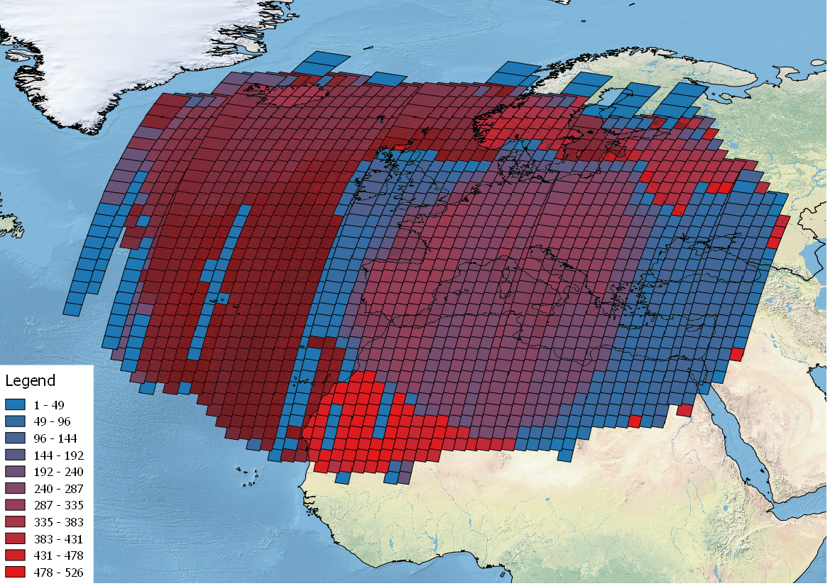
- Kiruna density and coverage map - Map (describedby)
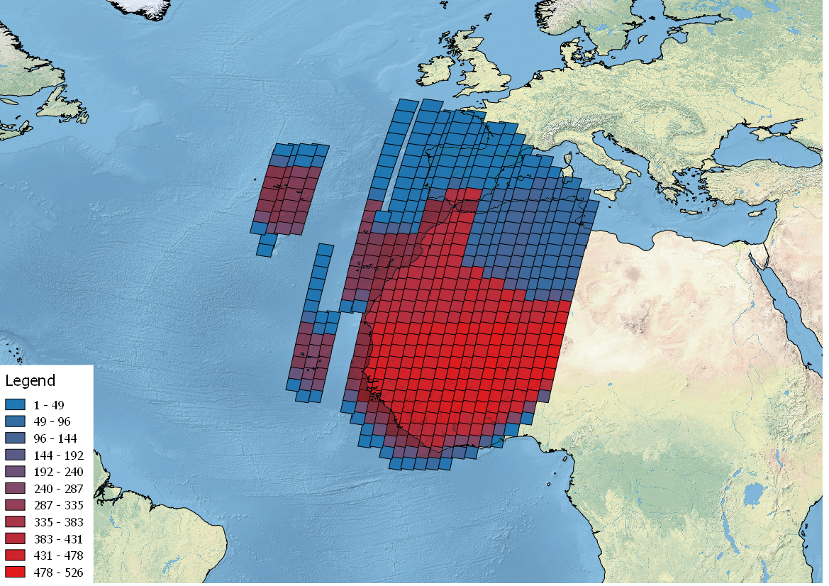
- Maspalomas density and coverage map - Map (describedby)
- Landsat Software Tools - Software Tools (describedby)
- Get Help? - ESA Earth Observation User Services Portal (describedby)
- Atom format (alternate)
- Dublin Core metadata (alternate)
- JSON-LD metadata (alternate)
- JSON-LD (schema.org) metadata (alternate)
- JSON-LD (GeoDCAT-AP) metadata (alternate)
- RDF/XML metadata (alternate)
- RDF/XML (schema.org) metadata (alternate)
- RDF/XML (GeoDCAT-AP) metadata (alternate)
- Turtle metadata (alternate)
- Turtle (schema.org) metadata (alternate)
- Turtle (GeoDCAT-AP) metadata (alternate)
- LS03_RFUI_MSS_GEO_1P_19790211T072736_19790211T072805_004781_0187_0028_8BA1 (item)
- LS03_RFUI_MSS_GEO_1P_19790211T073005_19790211T073034_004781_0187_0034_230B (item)
- LS03_RFUI_MSS_GEO_1P_19790212T073116_19790212T073145_004795_0188_0023_6623 (item)
- LS03_RFUI_MSS_GEO_1P_19790212T073435_19790212T073504_004795_0188_0031_1184 (item)
- LS03_RFUI_MSS_GEO_1P_19790212T091701_19790212T091730_004796_0206_0029_DFAC (item)
- LS03_RKSE_MSS_GEO_1P_19790212T091227_19790212T091257_004796_0206_0018_67CA (item)
- LS03_RFUI_MSS_GEO_1P_19790213T073724_19790213T073753_004809_0189_0024_3568 (item)
- LS03_RFUI_MSS_GEO_1P_19790213T110331_19790213T110400_004811_0225_0023_5E75 (item)
- LS03_RFUI_MSS_GEO_1P_19790214T074447_19790214T074516_004823_0190_0028_10B4 (item)
- LS03_RFUI_MSS_GEO_1P_19790215T093143_19790215T093213_004838_0209_0023_CE19 (item)
- LS03_RFUI_MSS_GEO_1P_19790216T075705_19790216T075735_004851_0192_0030_101E (item)
- LS03_RFUI_MSS_GEO_1P_19790216T111928_19790216T111957_004853_0228_0020_7963 (item)
- LS03_RKSE_MSS_GEO_1P_19790218T094308_19790218T094337_004880_0212_0009_E721 (item)
- LS03_RFUI_MSS_GEO_1P_19790219T081236_19790219T081306_004893_0195_0026_AAEE (item)
- LS03_RFUI_MSS_GEO_1P_19790219T095143_19790219T095212_004894_0213_0016_71A5 (item)
- LS03_RFUI_MSS_GEO_1P_19790216T111903_19790216T111932_004853_0228_0019_B4FA (item)
- LS03_RFUI_MSS_GEO_1P_19790222T083356_19790222T083426_004935_0198_0036_9BBF (item)
- LS03_RKSE_MSS_GEO_1P_19790222T064541_19790222T064610_004934_0180_0024_0CE2 (item)
- LS03_RFUI_MSS_GEO_1P_19790219T095552_19790219T095621_004894_0213_0026_F2A1 (item)
- LS03_RFUI_MSS_GEO_1P_19790220T095905_19790220T095936_004908_0214_0020_4AAC (item)
- First items (first)
- Next items (next)
- Last items (last)