CartoSat-1 archive and Euro-Maps 3D Digital Surface Model
CartoSat-1 (also known as IRS-P5) archive products are available as PAN-Aft (backward), PAN-Fore (forward) and Stereo (PAN-Aft and PAN-Fore). - Sensor: PAN - Products: PAN-Aft (backward), PAN-Fore (forward), Stereo (PAN-Aft+PAN-Fore) - Type: Panchromatic - Resolution (m): 2.5 - Coverage (km x km): 27 x 27 - System or radiometrically corrected - Ortho corrected (DN) - Neustralitz archive: 2007 - 2016 - Global archive: 2005 - 2019 Note: - Resolution 2.5 m. - Coverage 27 km x 27 km. - System or radiometrically corrected. For Ortho corrected products: If unavailable, user has to supply ground control information and DEM in suitable quality, - For Stereo ortho corrected: only one of the datasets will be ortho corrected. Euro-Maps 3D is a homogeneous, 5 m spaced digital surface model (DSM) semi-automatically derived from 2.5 m in-flight stereo data provided by IRS-P5 CartoSat-1 and developed in cooperation with the German Aerospace Center, DLR. The very detailed and accurate representation of the surface is achieved by using a sophisticated and well adapted algorithm implemented on the basis of the Semi-Global Matching approach. In addition, the final product includes detailed flanking information consisting of several pixel-based quality and traceability layers also including an ortho layer. Product Overview: - Post spacing: 5m - Spatial reference system: DD, UTM or other projections on WGS84 - Height reference system: EGM96 - Absolute vertical accuracy: LE90 5-10 m - Absolute Horizontal Accuracy: CE90 5-10 m - Relative vertical accuracy: LE90 2.5 m - File format: GeoTIFF, 16 bit - Tiling: 0.5° x 0.5° - Ortho Layer Pixel Size: 2.5 m The CartoSat-1 products and Euro-Maps 3D are available as part of the GAF Imagery products from the Indian missions: IRS-1C, IRS-1D, CartoSat-1 (IRS-P5), ResourceSat-1 (IRS-P6) and ResourceSat-2 (IRS-R2) missions. ‘Cartosat-1 archive’ collection has worldwide coverage: for data acquired over Neustrelitz footprint, the users can browse the EOWEB GeoPortal catalogue (http://www.euromap.de/products/serv_003.html) to search archived products; worldwide data (out the Neustrelitz footprint) as well as Euro-Maps 3D DSM products can be requested by contacting GAF user support to check the readiness since no catalogue is available. All details about the data provision, data access conditions and quota assignment procedure are described into the Terms of Applicability available in Resources section.
Links
- CartoSat-1 data user handbook - Product Specifications (describedby)
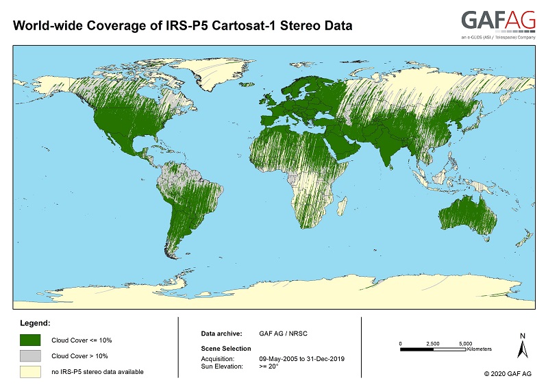
- Euro-Maps 3D available data map - Map (describedby)
- Euro-Maps 3D product description - Product Specifications (describedby)
- Euro-Maps 3D product format and naming conventions - Product Specifications (describedby)
- Cartosat-1 L1 and L2 product format - Product Specifications (describedby)
- EOWEB GeoPortal Catalogue - Catalogue (describedby)
- Indian Data Terms of Applicability - Access guide (describedby)
- Cartosat Product Guide - Product Guide (describedby)
- Get Help? - ESA Earth Observation User Services Portal (describedby)
- Atom format (alternate)
- Dublin Core metadata (alternate)
- JSON-LD metadata (alternate)
- JSON-LD (schema.org) metadata (alternate)
- JSON-LD (GeoDCAT-AP) metadata (alternate)
- RDF/XML metadata (alternate)
- RDF/XML (schema.org) metadata (alternate)
- RDF/XML (GeoDCAT-AP) metadata (alternate)
- Turtle metadata (alternate)
- Turtle (schema.org) metadata (alternate)
- Turtle (GeoDCAT-AP) metadata (alternate)