TropForest- ALOS, GEOSAT-1 & KOMPSAT-2 optical coverages over tropical forests
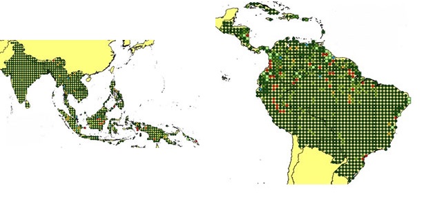
The objective of the ESA TropForest project was to create a harmonised geo-database of ready-to-use satellite imagery to support 2010 global forest assessment performed by the Joint Research Centre (JRC) of the European Commission and by the Food and Agriculture Organization (FAO). Assessments for year 2010 were essential for building realistic deforestation benchmark rates at global to regional levels. To reach this objective, the project aimed to create a harmonised ortho-rectified/pre-processed imagery geo-database based on satellite data acquisitions (ALOS AVNIR-2, GEOSAT-1 SLIM6, KOMPSAT-2 MSC) performed during year 2009 and 2010, for the Tropical Latin America (excluding Mexico) and for the Tropical South and Southeast Asia (excluding China), resulting in 1971 sites located at 1 deg x 1 deg geographical lat/long intersections. The project finally delivered 1866 sites (94.7% of target) due to cloud coverages too high for missing sites
Links
- More about TropForest - Other (describedby)
- Available products in TropForest dataset map - Available products in TropForest dataset (dark green, light green and blue circles) (describedby)
- Get Help? - ESA Earth Observation User Services Portal (describedby)
- Atom format (alternate)
- Dublin Core metadata (alternate)
- JSON-LD metadata (alternate)
- JSON-LD (schema.org) metadata (alternate)
- JSON-LD (GeoDCAT-AP) metadata (alternate)
- RDF/XML metadata (alternate)
- RDF/XML (schema.org) metadata (alternate)
- RDF/XML (GeoDCAT-AP) metadata (alternate)
- Turtle metadata (alternate)
- Turtle (schema.org) metadata (alternate)
- Turtle (GeoDCAT-AP) metadata (alternate)
- 2009 (child)
- 2010 (child)
- 2011 (child)